Wednesday, July 3, 2024


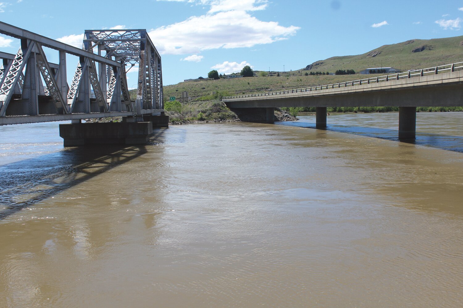


BREWSTER – Major and deadly flood events in Texas, West Virginia, Kentucky, and Nevada in just the past 30 days have been making national news lately and while nothing of that magnitude has been a hazard here, city officials in Brewster, Pateros, and Bridgeport have been addressing excess water events in their jurisdictions.
Brewster
“In the past we have had some rain events that has caused some flooding.” said city finance director Misty Ruiz of water that comes down from the Rat Lake drainage north of Brewster, “There is drainage that goes under some of the businesses and the highway, so it floods right there.”
Ruiz and public works director Lee Webster had already been discussing future strategies to apply for funding to help resolve the Rat Lake drainage in a few years when an advisory from FEMA moved up the timetable. At the August city council meeting Webster reported that FEMA had expanded Brewster’s floodway based on updated data and modeling. The new FEMA designation could compel many city residences and businesses to acquire flood insurance.
To head off the new FEMA actions the city is contacting the National Resource Conservation Service to help the city correct its potential flooding issue.
“I’m hoping FEMA will allow us some extra time once we show them that we are going to solve the problem,” said Ruiz. “It’s going to take us probably five years to deal with it, so we are going to need an extension.”
One idea involves creating an impoundment between Rat Lake and city structures and utilize that impounded water to be routed back into the city’s aquifer.
“The excess water is not serving any good purpose for irrigating or recharging the city’s aquifer,” Ruiz said.
Pateros
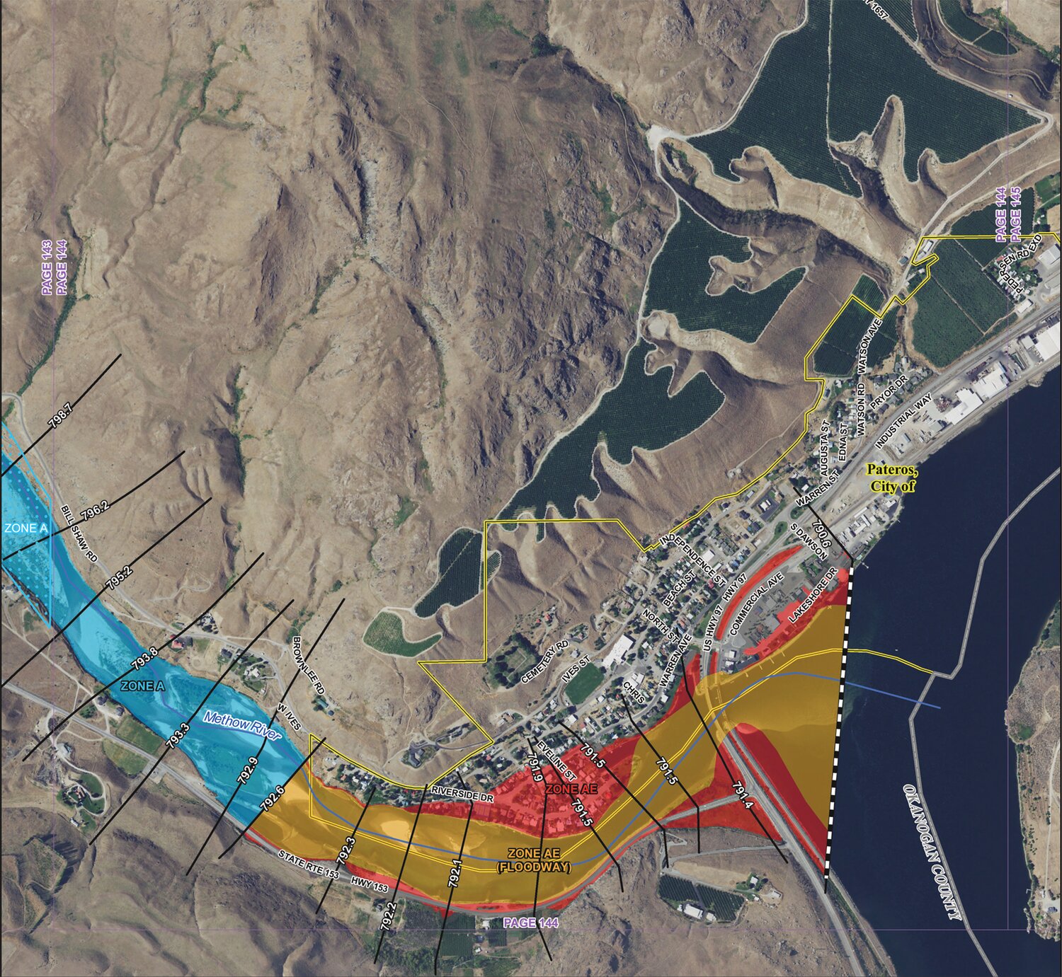
Last year when FEMA advised the City of Pateros that the agency’s data suggested that portions of the city adjacent to the Methow River were included in an expanded flood plain area, city administrator Jord Wilson did not agree.
“They were using only the data out of the Methow Valley and watershed to predict the flood plain in Pateros,” said Wilson. “The initial FEMA plan that came out included all the lower fill area from Warren Street to Peninsula and out to the tennis courts,”
Wilson argued that Wells Dam can be lowered in minutes to control excess water.
“All of Pateros is affected by Wells Dam, but FEMA said it was not going to consider the Columbia River, only the Methow.”
Wilson pointed out that the dam has been able to quickly respond to major events like the 1972 flood. In May 2018, the county experienced the worst flooding since 1972 and while water levels were high at the confluence of the Okanogan and Methow rivers, Pateros again was not affected.
FEMA later included the Columbia in its Pateros assessment. As a result, the latest FEMA map removed the added areas in Pateros.
“Í don’t believe there is going to be any change to our flood plain in this new assessment,” Wilson said.
Bridgeport
Public works superintendent Stuart Dezellem said he has not heard from FEMA but is addressing some excess water issues in the Raymond and Fifth areas, the top two residential streets on the south side of the city.
“This new flooding is not coming down what was constructed to deal with it which was to bring it down behind the high school, bring it down 11th Street,” said Dezellem. “What caused the flooding was coming further from the east.”
Some state funding will help the city address the problem and options to fix it.
“We just got some grant money through the Department of Ecology to do a storm drain plan,” said Dezellem. “Sometime in 2023 we’re going to start working on a plan.”
Dezellem said he is consulting old city maps and other sources to see what the city has done in the past.
“I know some modeling has been done in the past when the ’91 flood happened,” said Dezellem. “It will be interesting.”


Comments
No comments on this item Please log in to comment by clicking here